Ascent: 1,500ft/ 470m
Length: 10.5 miles/ 17km
Map: Explorer 026 North York Moors West
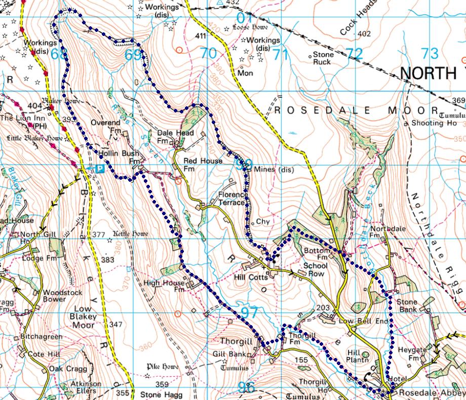
Rosedale is one of the largest and most impressive valleys in the North York Moors, and the only one of the central dales (Rosedale, Farndale, Bransdale and Bilsdale) to contain a sizable village, Rosedale Abbey. Rosedale is perhaps best known for its industrial ruins, particularly those of East Mines, while for me the best thing about the valley is the abandoned Rosedale Railway, which can be followed on foot around most of the valley. The most impressive stretch runs around the upper reaches of the valley, following a route half way between the valley floor and the open moorland above, and taking us all the way around the wild head of the valley. The 'abbey' of Rosedale Abbey was actually a Cistercian priory, founded in 1158 by William of Rosedale. At its peak it probably only contained nine nuns and a prioress, and only scanty remains can now be seen, close to the current church. Many more dressed stones from the priory can be seen in the village buildings, used during the massive expansion that accompanied the mining boom of the nineteenth century. For many centuries Rosedale was shaped by the ironstone mines. In the thirteenth century Byland Abbey was granted rights to the iron ore in Rosedale, and produced iron in the valley until the sixteenth century. Interest in the Rosedale ironstone was revived during the nineteenth century. By 1850 samples had been taken away to be smelted, and it was discovered to be high quality magnetic iron ore, with a 45% iron yield (compared to 30% at the better end of the Skinningrove ore field). Mines were soon opened, but the biggest problem was how to transport the heavy iron to the iron foundries of Teesside. The solution was a railway that ran around the head of Farndale from Greenhow Moor to Blakey Junction, just to the south of the Lion Inn on Blakey Rigg. This line was built by 1861, and was connected to the main railway network by the steep Ingleby Incline. Laden iron ore wagons were sent down the incline, while the engines remained at the upper level, rarely leaving the moors. A network of smaller tramways then connected Blakey Junction to the mines. East Mines, which now boast the most substantial remains, was connected by 1865. Another line ran south to mines at the southern end of Rosedale, sitting on the western slopes of the valley, at the foot of another incline. This ran down from Bank Top, close to the site of the old Rosedale Chimney, demolished in 1972 for safety reasons. This railway didn't just serve the Rosedale mines, but was also used by Blakey Mines, on the eastern side of Farndale. Part of the railway south from the junction towards these mines can still be traced on the ground, before ending very suddenly, while another incline once connected the mine itself to the railway. Rosedale is flanked on the west by Blakey Ridge, one of the most impressive of the moorland ridges that separate the valleys. Young Ralph Cross, the basis of the National Park's logo, is located at the head of the ridge, near a small parking area close to a road junction where one of the roads out of Rosedale joins the road along the ridge. The top of the ridge is a stunning viewpoint, with views down Rosedale and north towards Eskdale and the sea.
This walk takes us though the rugged scenery of upper Rosedale, using the old
iron railway for most of its route. This is a fantastic walking route,
travelling at a high level around the side of the valley, giving impressive
views across Rosedale at all times. The route also passes by some very
substantial industrial ruins, a reminder of the original purpose of the railway.
For the last part of the walk we come off the hills and follow the valley
bottom, meeting up with the River Seven, last seen at the very northern tip of
the valley.
Ascent: 1,500ft/ 470m
Length: 10.5 miles/ 17km
Map: Explorer 026 North York Moors West
Start from the free car park on the road east out of Rosedale Abbey. This is
a popular village, so on a busy summer day this car park may well fill early.
1 (SE 725 960) - A footpath leaves our car park heading north along the line of
Northdale Beck. Take this path and follow it as it runs through a series of
fields. At one point a permissive footpath is signposted that stays closer to
the stream than the official right of way - take this permissive path.
2 (SE 724 972) - After just under a mile we reach a public footbridge over the
beck. Cross this bridge and follow the path that continues to head north, still
generally following the line of Northdale Beck while also gently climbing up the
side of the hill. Our path crosses the side road that leads into North Dale, and
then begins to climb rather more steeply up the side of the hill. Towards the
top of this climb there is now small reservoir, which we pass to the left.
3 (SE 718 978) - Just after passing this reservoir our path joins a track at a
t-junction. Turn left onto this track, and follow it until it curves slightly to
the left. Here a footpath leaves to the right, cutting across to a road. Take
this footpath. At the road turn right. After a very short distance on the road a
footpath turns left and leads into a small plantation. Take this footpath. We
are now on the track of the Rosedale Railway. Follow the railway as it runs
north west through the trees.
4 (SE 711 981) - Our route is nice and simple until we reach the tip of a side
valley, crossing a small stream. Here we have to divert from the railway, which
becomes muddy and impassible. Our route heads to the left of the railway and
falls away as it goes. At the edge of the trees a path leads west, passing to
the south of Clough House. At the far side of the house, our path joins a track,
which runs south west along the edge of the trees. Follow this track until it
joins a second farm track at a t-junction.
5 (SE 708 977) - At the t-junction turn right, and follow the track uphill as it
passes through a farmyard. Just beyond the farm, the track swings away to the
left, while the signposted right of way continues north up the hill. Ignore the
right of way and turn left to follow the track (which runs across access land at
this point to reach the railway). We are now close to the railway again, as
demonstrated by the industrial remains. As we cross this wide flat area the
route of the railway is not entirely clear, but as we reach the far end all
becomes clear - the railway itself runs to the left of the bank that has been
visible since we turned left. From here the route onwards becomes clear for just
under five miles - follow the route of the railway as it runs up the eastern
side of Rosedale, past a series of impressive industrial ruins, curves around
the top of the valley and begins to head back south down the valley.
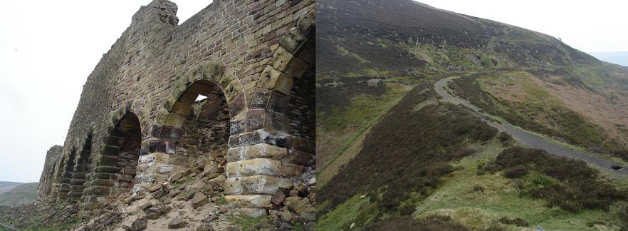
6 (SE 684 988) - We remain on the track of the railway until we reach the point
where the railway crossed over into Farndale. The first warning that we are
approaching this point comes when a farm track crosses the railway heading down
into Rosedale. Just under a quarter of a mile later, we reach the crossing
point, and the car park on Blakey Ridge. Here a right of way is signposted
heading straight down the side of the bank (see picture). Turn left and follow
this path.
7 (SE 687 989) - Our path now meets up with the farm track again. The right of
way is shown as crossing the field on the far side of the track, but the path
doesn't appear to exist on the ground, so instead follow the track down and to
the right.
8 (SE 691 989) - This track leads into Moorlands Farm. Just past the entrance to
the farm a footpath is signposted heading off to the right. Turn right and
follow this path. The path runs through a series of fields before reaching
Daleside Road, at this point more of a farm track. Continue south along this
track as it heads down Rosedale towards Thorgill.
9 (SE 707 965) - We follow this path past the first buildings in Thorgill,
before crossing a stile that leads into a field to the left (on a signposted
footpath). Our route through this field is slightly complicated. The OS map
shows a small plantation to our right, with a wall just beyond it, and a foot
bridge in the far right corner of the field. That wall no longer exists. On
passing the small plantation another small group of trees come into sight, Our
bridge is tucked away just behind these trees. On the far side of this bridge we
find ourselves on a narrow strip of open land with trees and a stream to the
left and Low Thorgill Farm to the right. Head down this strip of land.
10 (SE 710 967) - The path emerges into the next field on a slight ridge. Here
the stream swings away to the left and then back to the right. Head straight on
in the same direction we have just come from, aiming for the trees directly
ahead (and slightly downhill). Here there is another bridge over the stream. On
the far side of this bridge there are two paths. One continues straight on
across the field. Ignore this path and instead turn right and follow the path
that follows the line of the stream. This path soon joins a farm track and
follows it through the next two fields.
11 (SE 712 968) - In the second field the track follows the right hand border of
the field, before swinging around to the left. At the tip of this curve a
footpath is signposted heading through a gate. Turn right onto this path, and
follow it all the way back into Rosedale Abbey. Pick your own way back through
the streets of the village to your starting point.
Ed Amis, Anne Boe, Alan Bradbury, Bernie Cowan, Garry Cowan, Bob Dixon, Lynn Ford, Anne Marie Forster, Martin Hedley, Hedley Oliver, Graeme Page, Lisa Philliskirk, Madeleine Philliskirk & Ronnie Willison travelled on the minibus to Rosedale, one of the largest and most impressive valleys in the North York Moors.